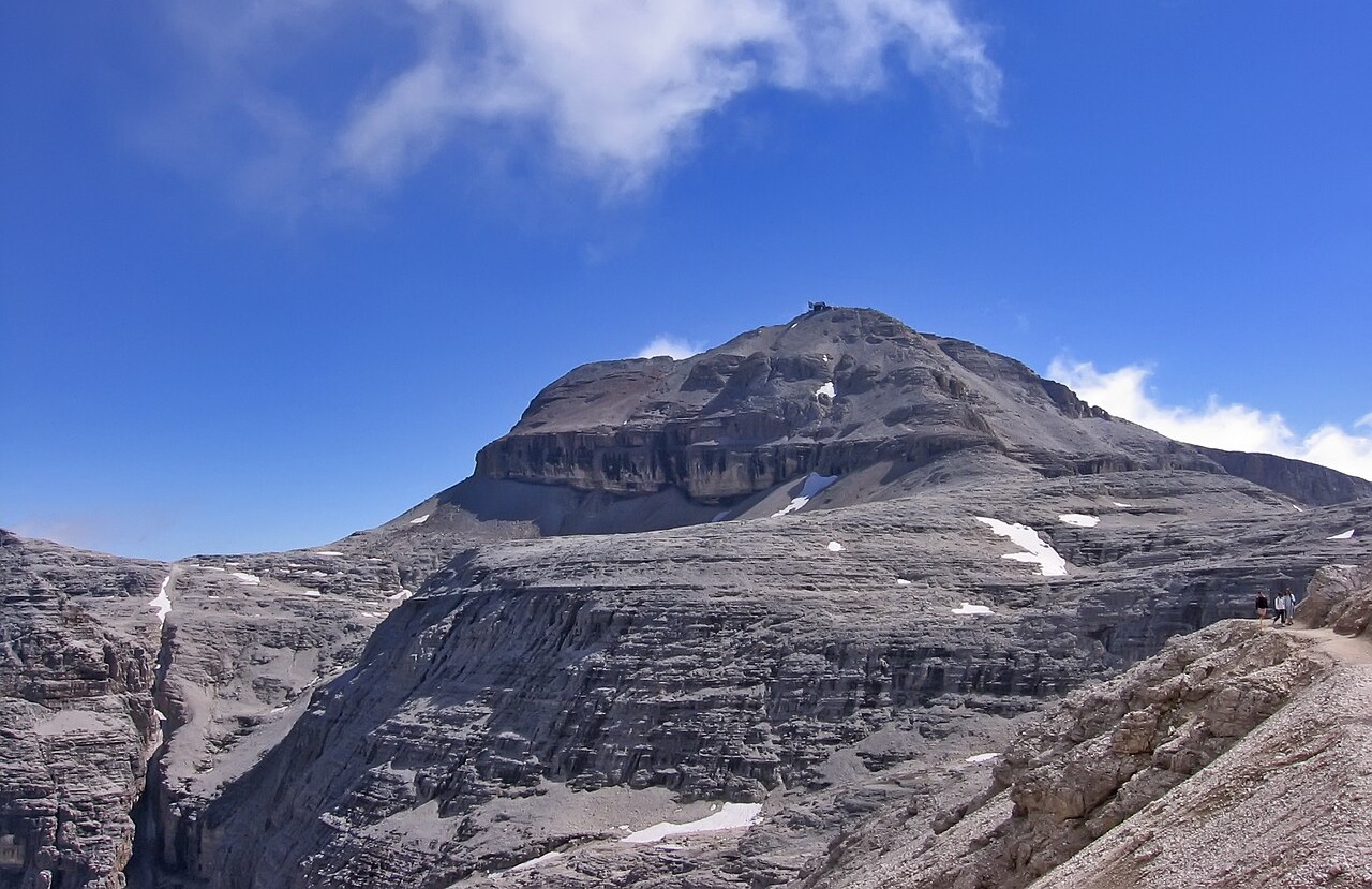
Piz Boè, 3,152 m — the roof of the Traumpfad, with the Capanna Fassa hut on its summit.
It’s Oktoberfest, and half the world is on its way to Munich.
So are we — but don’t worry, TrailQuest hasn’t changed genre. This is still a walking app. We’re not here for the beer tents. We’re here for a square twenty minutes’ walk from them, where a trail begins that doesn’t stop until it reaches the sea.
It starts at Marienplatz. It ends at Piazza San Marco in Venice. In between are the Alps.
It’s called Der Traumpfad — the Dream Path — and it’s the ninth trail in TrailQuest. To mark the occasion, the app now also speaks German.
The Night Below the Snowline
I should explain how I ended up here, because it didn’t start with Munich. It started with a mistake in Switzerland.
In 2018 I walked the Via Francigena, the old pilgrim road to Rome. Somewhere past Lake Geneva it climbs towards the Great St Bernard Pass, the crossing from Switzerland into Italy. It’s the pass Napoleon took his army over in 1800, and the pilgrim route follows his footsteps up the valley, steadily, sensibly, the way people have crossed there for a thousand years.
I left those footsteps. Not carefully — I just decided I wanted something higher, and took a high alpine route instead: seven mountain passes, all of them above 3,000 metres, in place of one much gentler pilgrim crossing.
It got dark before the sixth pass.
I made the sixth one anyway, in the dark. Then I looked at the seventh. In front of me was a wall of rock standing up black against a sky so full of stars it didn’t look real, and I understood that going over it that night was the kind of decision people don’t come back from.
So I stopped. I bivouacked just below the snowline, in what I had with me, and shivered my way through the coldest night of my life. But the cold was never what was going to kill me. The wall was. One wrong step on that rock in the dark would have been the last one.
In the morning the wall was just a mountain again. I crossed the last pass in daylight and walked down to the Col du Grand-Saint-Bernard and the hospice at the top of the old road.
And I love remembering it. Which is probably why, ever since, I keep looking at maps of the Alps and asking where else you can walk across them.
The Dream Path
That’s how I found the Traumpfad.
In August 1974, Ludwig Graßler — a horticultural adviser from Wolfratshausen, just south of Munich — set off from the Marienplatz to find out whether a person could still simply walk to Venice: out of the city, over the Alps, all the way to the Adriatic. About four weeks later, he was there.
Three years later, in 1977, he published the route as a book of twenty-eight daily stages. People started walking it, and they never stopped. I knew none of this when I started reading. What surprised me was how known it is: in Germany, and in the German-speaking countries around it, the Traumpfad isn’t a niche hiking route. It’s a cultural reference. People who have never owned a pair of hiking boots know what “München–Venedig zu Fuß” means.
So when I had to decide which trail would come out alongside the German version of the app, there wasn’t really a decision to make.
It was always going to be Der Traumpfad.
The Trail
What makes it extraordinary isn’t any single summit. It’s the continuity — one unbroken line from a city square to a sea.
You leave Marienplatz on an ordinary morning and follow the Isar out of Munich, past Kloster Schäftlarn and the rafting town of Wolfratshausen, and for two days you’ll wonder whether this counts as mountaineering.
Then the ground tilts. The Benediktenwand stands at the front of the range like a doorman. Behind it is the Karwendel — naked limestone, valleys like the teeth of a comb, and the Lafatscher Joch at 2,081 metres. Graßler’s original line stays high here and comes down the Halltal to the Inn, instead of taking the detour into Innsbruck that many modern itineraries prefer.
Across the Inn, the Tuxer Alps turn green and grassy, and the trail climbs past the glaciers of the Zillertal to the Pfitscher Joch, 2,246 metres: the main ridge of the Alps and the border. Water on one side runs to the Black Sea, on the other to the Adriatic you’re walking towards. You cross into South Tyrol, where the signs change language twice and the German stays.
Then the Dolomites — the most vertical part of the walk. Over the Würzjoch, the Grödner Joch, and up the Sella to Piz Boè at 3,152 metres, the roof of the whole journey. Past the Marmolada and its shrinking glacier, down to Alleghe, a village on a lake created by a landslide in 1771, and up again under the north-west face of the Civetta, which climbers call the wall of walls. The last mountains are the wild Schiara group, and then — suddenly — Belluno, a Venetian town on a terrace above the Piave, and the end of the Alps.
From there it’s flat: Prosecco hills, the Piave and its First World War memory, maize and vines and long straight roads, until the Adriatic finally appears at Jesolo.
At Punta Sabbioni the road simply runs out at the edge of the lagoon. No walking route has ever crossed that water. So everyone who has walked from Munich since 1974 has finished the same way: standing on a jetty with a rucksack among day-trippers, waiting for a boat.
The Last Nine Kilometres Are by Boat
We kept that in the app.
The final stretch from Punta Sabbioni to Piazza San Marco is a vaporetto ride across the lagoon, and in TrailQuest it’s a terrain effect: your steps carry you 1.5× faster for those last 9.4 kilometres, because that’s what a boat does. It’s the first time a terrain effect on one of our real-world trails speeds you up instead of slowing you down.
The rest of the trail goes the other way. The Karwendel, the main Alpine ridge, the Dolomites and the Schiara are all slow ground, and the app treats them that way.
In numbers: 533 kilometres, 32 milestones, 31 day stages, six sections from the Alpine foothills to the Piave plain, three languages along the way, and one boat at the end.
Sechste Sprache
TrailQuest started in English. Spanish came with the Camino, French with the GR20, Portuguese with the Fishermen’s Trail, Slovak as a thank-you to the people who tested the app when it was barely working.
German is the sixth, and it comes with the Traumpfad — the whole interface, every trail, every badge, every milestone story.
I’ll be honest about one thing: I don’t speak German natively, and this translation hasn’t yet been read by someone who does. If you’re a German speaker and something sounds wrong, I genuinely want to hear about it.
And a small confession, since we’re being honest: more than half of this trail is in Italy. Past the Pfitscher Joch you’re in South Tyrol, where people still speak German, but after that come Ladin valleys, Italian ones, and finally Venice. It’s not only a German trail. But it starts in Munich, it’s known by its German name, and everyone who knows it, knows it in German. That’s good enough for me.
Go Walk It
The real Traumpfad takes most people four weeks, and it’s best walked from July to mid-September, when the high passes are clear of snow. It’s a serious mountain route in places — the Dolomites and the Schiara include exposed sections — but huts and villages are spaced for daily stages almost the whole way.
Whether you’re in Munich this week for the Wiesn — that’s what Munich calls the Oktoberfest, after the Theresienwiese meadow it’s held on; not to be confused with Weizen, the wheat beer that Bavarians call Weissbier — or not, find your way to Marienplatz one day and look south. That’s the direction.
And if you can’t take four weeks off — walk it from home, one day at a time. That’s what the app is for.
Walk from Munich to Venice from your front door
TrailQuest turns your daily steps into real progress on legendary trails — with trail lore, HealthSpan Score, and streaks that keep you going. Now in English, Español, Français, Português, Slovenčina and Deutsch. Free on Android.
▶ Get TrailQuest on Android