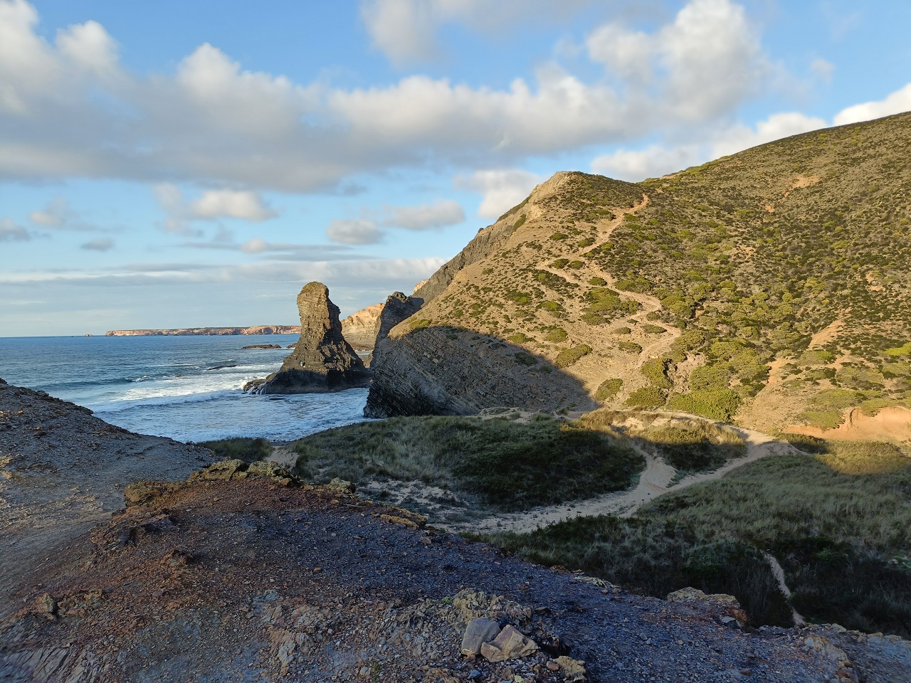
The west coast of the Rota Vicentina. Cliffs, a sea stack, and the thin line of path above the beach.
The Camino Português starts in Lisbon. Six hundred and twenty kilometres to Santiago, up through Tomar and Coimbra and Porto and the green north. It is a real Camino, an old one, and by any sane measure it is long enough.
I looked at the map and thought: that’s three weeks.
Most pilgrims who want more distance solve this by starting further back along the route. There is nothing further back. Lisbon is the beginning. So I did the only other thing available — I went looking for a way to arrive at Lisbon on foot, from the south, and give myself a longer walk than the Camino itself.
What I found was a trail built by people gathering shellfish off wet rock.
The Coast Nobody Built On
Portugal’s southwest corner is the longest stretch of undeveloped coastline left in southern Europe. Not a national park in the American sense, not fenced or ticketed — just a coast that, through a combination of protection and bad luck for developers, never got its wall of hotels. Cliffs, dune fields, storks nesting on sea stacks, and villages that still smell of fish rather than sunscreen.
Running along the top of those cliffs is a network of paths called the Rota Vicentina. It has two main arteries. The Historical Way runs inland through cork oak and farmland. The Fishermen’s Trail — Trilho dos Pescadores — stays out on the edge, as close to the Atlantic as a footpath can reasonably get.
The Fishermen’s Trail is not a scenic route that happens to pass the sea. That distinction matters. These paths existed long before anyone thought to waymark them, and they existed for a reason: the men and women of these villages walked them daily to reach the rocks where percebes grow. Goose barnacles — the strange, expensive, prehistoric-looking shellfish that clings to the most violently exposed rock on the coast and is harvested, still, by people timing the sets between waves.
You are walking a commute. It just happens to be the most beautiful commute in Europe.
Where the Name Comes From
The whole network is named after a cape, and the cape is named after a body.
Cabo de São Vicente is the southwestern tip of Europe — the last land before the Atlantic, which the Romans knew as the Promontorium Sacrum, the sacred promontory, and considered the edge of the inhabited world. Somewhere in the early medieval period the relics of St. Vincent of Saragossa, martyred in Valencia, are said to have ended up here, in a small church on the headland, guarded — the legend insists on this detail — by ravens.
In 1173, Afonso Henriques, the first king of Portugal, had those relics moved by sea from the cape north to Lisbon. The ravens, the story goes, escorted the ship the whole way. Lisbon’s coat of arms still shows that ship with a raven at each end.
That relic voyage runs the length of this coast, south to north, from the cape to the capital.
It is also, almost exactly, the walk.
Which Way to Walk It
Nearly every guidebook, every GPX file, every organised tour runs the Fishermen’s Trail north to south — Porto Covo down to Lagos. There are good practical arguments for it, mostly about the prevailing northerly wind being at your back.
I walked it the other way, and so does the trail in TrailQuest.
Partly that was logistics: I needed to end near Lisbon, not start there. But once I understood the St. Vincent story, the direction stopped feeling like a compromise and started feeling like the point. You begin on the sheltered south-facing Algarve coast, where the walking is easy and the water is calm. You turn the corner at Cabo de São Vicente. And then the coast changes character completely — for the next 170 km you are on the exposed west side, in Atlantic weather, walking north.
The same way the relics went.
The trail finishes on the beach at São Torpes, which is named after another saint the sea delivered: Torpes, beheaded in Pisa and set adrift in a boat with a dog and a rooster, whose body — the legend says — came ashore right here.
Two saints, two directions of the sea, one footpath between them.
What It’s Actually Like
Here is the thing nobody warns you about: the Fishermen’s Trail has almost no elevation, and it is hard.
No passes, no sustained climbs — and walkers still rate it harder than the numbers suggest.
The reason is entirely underfoot. It’s sand. Not beach sand you cross for ten minutes — deep, dry, unconsolidated dune sand, on the clifftops, for kilometres at a stretch. Every step gives back a portion of itself. The dune field past Praia da Bordeira is the section people remember, and not fondly. Add the wind, which on the west coast has crossed the Atlantic uninterrupted and is not slowed down by anything between you and Newfoundland.
The trail is currently 13 official stages and roughly 226 km, Porto Covo to Lagos. Villages every day, so you are never carrying more than a day’s water. Sagres, Carrapateira, Arrifana, Odeceixe, Zambujeira do Mar, Almograve, Vila Nova de Milfontes — each one a place you would happily lose a rest day in.
Not one of them is a resort.
Sines, and the Beach That Doesn’t Stop
At São Torpes the waymarked trail ends. I kept going.
North of Sines the coastline changes again: the cliffs give out and the Costa Alentejana opens into what people around there will tell you, with some justification, is the longest continuous beach in Europe. Sand from Sines to the Sado estuary at Tróia, running dead straight for the better part of sixty kilometres, with the dunes on your right and nothing at all on your left.
Walking that is a strange experience. On a cliff path the view changes every twenty minutes. On that beach the view does not change for a day and a half. You stop navigating and start simply enduring, in the good sense — the sort of walking where you finally run out of things to think about.
From Tróia I crossed the estuary, worked up through Setúbal, and arrived in Lisbon on foot from the south. Which was the entire point.
And then, the next morning, I started the Camino Português.
Four weeks. One direction. North.
The Trail Is Now in TrailQuest
Trilho dos Pescadores (Rota Vicentina) is live in TrailQuest as of version 1.3.2 — the seventh trail in the app and the first paid trail in the Real World category.
- 221.50 km, Lagos → São Torpes
- 13 stages, matching the official Rota Vicentina staging
- 15 milestones, from the Lagos waterfront to the beach at São Torpes
- 3 sections with real geographical borders, not arbitrary thirds: the sheltered Algarve coast to Sagres, the wild west coast from the cape to the Seixe river, and the Alentejo shore beyond it
- Direction: NOBO, for the reasons above
Every distance in it was measured off the route itself rather than copied from a guidebook — each village snapped to its nearest point on the track. When the stage boundaries fell out of that process they matched the 13 official stages, which was a good sign that both the track and the method were sound.
There’s one design detail I’m quietly pleased with. TrailQuest has terrain zones that slow your progress on hard ground, and on most trails those zones mark altitude. On this one they mark sand. The dune field past Bordeira is the slowest ground in the app.
Why This Trail Costs Something
Trilho dos Pescadores is a paid trail, on exactly the same terms as Everest Base Camp. It’s worth explaining the logic, because “paid” is the wrong word for what actually happens.
The unlock cost is 2× the trail’s length in kilometres, in Trail Coins.
All 443 come back to you when you finish it.
The milestone rewards along the route plus the completion bonus add up to precisely the unlock cost — 443 out, 443 in.
So it isn’t a paywall. It’s a deposit. You’re not buying access to the trail; you’re staking something on the commitment to walk 221 kilometres, and you get your stake back when you do. The trails that require serious work to research, map, and write are the ones that ask for that commitment up front.
This is the principle underneath the whole economy: a gate in TrailQuest should be a walking distance, not a price tag.
And It Speaks Portuguese
A Portuguese trail deserves a Portuguese app.
Version 1.3.2 adds Portuguese as TrailQuest’s fourth language, after English, Spanish and French. Not just the buttons and menus — the trail lore too, all of it, every milestone description on every trail in the app.
Specifically European Portuguese. Brazilian Portuguese has far more speakers and will come later, but this release is anchored to a trail that runs through the Alentejo and the Algarve, and it seemed wrong to describe Odeceixe in anything other than the Portuguese spoken there.
If you’re a native speaker and something reads oddly, please tell me. That’s not a formality — I don’t speak Portuguese well enough to catch everything, and the feedback genuinely gets acted on.
Go Walk It
If you’ve done a Camino and you’re looking for the next thing: this is the next thing. It’s wilder than the Francés, emptier than the Português, and it will hurt your legs in a way you don’t expect from a trail with no mountains on it.
Best seasons are spring and autumn. Summer is hot and the villages fill up. Winter is walkable but the Atlantic weather takes the decision out of your hands.
And if you can’t get there this year — walk it from home. That’s what the app is for.
Walk the Fishermen’s Trail from your front door
TrailQuest turns your daily steps into real progress on legendary trails — with trail lore, HealthSpan Score, and streaks that keep you going. Now in English, Español, Français and Português. Free on Android.
▶ Get TrailQuest on Android